About the Trail
Around the north end of Burt Lake
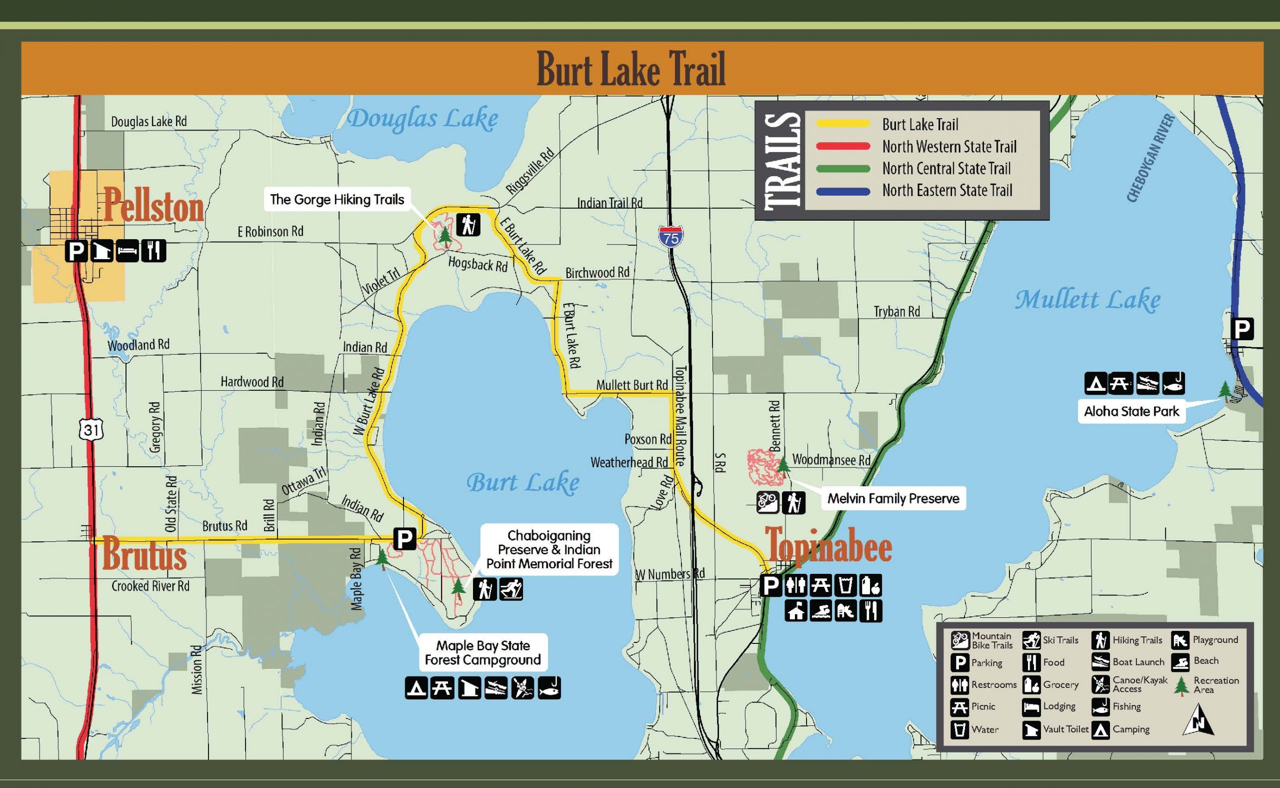
Gentle hills and views of shimmering water provide the background for the Burt Lake Trail. This trail provides a safer recreation and transportation route to bike, walk, and enjoy the gorgeous scenery around the north end of Burt Lake. With both paved and limestone surfaces, places to view the lake, connections to trails for hiking, and linking the North Western State Trail and the North Central State Trail, the Burt Lake Trail has it all.
History
Phase one of the Burt Lake Trail was completed in the fall of 2013: five miles of separated crushed limestone trail and paved shoulders running from Maple Bay Road on Brutus Road to Hogsback Road on West Burt Lake Road. Funding came from MDOT Transportation Enhancement Funds, the Michigan Natural Resources Trust Fund, and a local match of $140,000 raised from residents of Burt Township and residents and visitors from Cheboygan and Emmet counties, with contributions from the Burt Lake Preservation Association, the Tri-County Bicycle Association DALMAC Fund, area foundations, businesses, and the Indian River Kayak/Bike Biathlon.
Segments, west to east
Brutus to Maple Bay — 4 miles. From Brutus to Maple Bay Road is a future phase that will use 5–6-foot road shoulders, taking you from the North Western State Trail to Maple Bay Road. There the trail becomes separated and paved to the Chaboiganing Preserve. Maple Bay Road provides access to the Burt Lake Maple Bay boat ramp and the Maple Bay State Forest Campground. The preserve is adjacent to the Indian Point Memorial Forest, home to the Colonial Point Memorial Forest — one of the few old-growth forests left in the state, with 200-year-old red oaks — and together they offer 2.5 miles of hiking trails.
Chaboiganing Preserve to the University of Michigan Biological Station (The Gorge hiking trails) — 5.3 miles. This section mostly follows West Burt Lake Road, east of the road, past homes and cottages with views of the lake. The surface is both paved and crushed limestone, with sections upgraded as funding becomes available. Parking is available at the Chaboiganing Preserve trailhead.
The Gorge to Topinabee — 5.4 miles completed, 4 miles future. After exploring the Gorge (parking available), the next section of separated trail is paved until just past Birchwood Road, where it becomes 5-foot paved shoulders to Topinabee Mail Route Road. Future segments will continue improved road shoulders past the Melvin Family Hiking and Biking Trails toward Straits Highway and the North Central State Trail.
Topinabee. Parking is available at the Topinabee Public Library, with restrooms, a picnic area, water, a beach, a playground, food, and a historic site nearby.
Future plans
When completed, the Burt Lake Trail will connect the North Central State Trail to the North Western State Trail, creating a 67-mile looped trail, and will also connect to the state-endorsed Iron Belle Trail. Future segments will include widened shoulders along present roads and separated pathways where possible. The trail is a great example of collaborative effort — it could not have happened without the support of many individuals, organizations, and government agencies.
Route Map
Explore the route
Pan and zoom the interactive map, or open it full-screen in Google Maps.
Get Involved
Help keep this trail open
Trails are built and maintained by volunteers and donors. Join us.